
Click the image to view a large captioned map.
The canyons of Valles Marineris
Valles Marineris (Latin for Mariner's valleys, in honor of Mariner 9) is a vast system of canyons near the equator between Tharsis Montes to the west, and Margaritifer Terra to the east, in the quadrangles of
Phoenicis Lacus, Coprates and Margaritifer Sinus. Centered at 13.7ºS and 300.8ºE and extending over 3,770 km, its floor is commonly located 5 km below the Martian reference level while the plateaus it crosses have an altitude exceeding in places 5 km above the reference level, which leads to a difference in altitude generally close to 10,000 m.
It would be, for the whole, enormous lava flows which would have fractured and collapse ditches coming from the expansion forces of the Martian crust at work in all this region widened by erosion until reaching a width of 600 km. In the current state of our knowledge, it would be the most important structure of this type in the Solar System.
Because of its dimensions, Valles Marineris covers a set of well characterized regions.
Noctis Labyrinthus
The system of canyons originates, at the very west of the region, in Noctis labyrinthus, north of Syria Planum and southeast of Pavonis Mons, the central volcano of Tharsis Montes. It is a network of deep intersecting furrows fracturing a very high plateau, whose altitude exceeds 7,000 m above the reference level while the furrows are sometimes nearly 5,000 m deep. The surface of the plateau is believed to be of volcanic origin, originating from Tharsis Montes and Syria Planum. The terrain below the walls of these fractures has been shaped by different types of erosion, leading to quite variable morphologies, from the smoothest to the most chaotic.
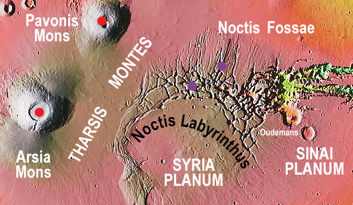
Tithonium Chasma and Ius Chasma
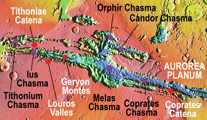
Valles Marineris begins, strictly speaking, at the level of the Oudemans crater, north of Sinai Planum. Two long parallel canyons constitute the western half of the system: Tithonium Chasma (810 km long) in the north, and Ius Chasma (938 km long) in the south. The latter is the wider and deeper of the two, and lies in the main axis of the formation. It is itself split longitudinally in two by Geryon Montes in its western part for nearly half its length, before widening by deepening in its eastern part. At this level, the surrounding plateau is slightly lower (about 4,000 m altitude) and the depth of Ius Chasma reaches 8,000 m in places. The bottom of these canyons consists mainly of debris from landslides, apparently facilitated by the undermining of molten water from the permafrost. A large number of transverse valleys cut the southern wall of Ius Chasma, notably Louros Valles.
Ophir Chasma, Candor Chasma et Melas Chasma
The central region of Valles Marineris is the one where three vast parallel canyons join in a single structure of about 600 km wide: Ophir Chasma (317 km long) in the extreme north, Candor Chasma (813 km long) in the extension of Tithonium Chasma, and Melas Chasma (547 km long) in the extension of Ius Chasma. This is the beginning of the deepest part of the region, with a bottom located more than 5,000 m below the reference level, resulting in an escarpment height of more than 9,000 m at this location. The highly variable nature of the terrain at the bottom of the three major canyons in this section indicates both eolian and volcanic origins, and ages ranging from Hesperian to Amazonian in some cases recent. Water action is also suspected through chaotic regions such as Candor Chaos.
Coprates Chasma
Melas Chasma is extended to the east by Coprates Chasma (966 km long), whose bottom averages 5,000 m below baseline while the surrounding plateaus peak locally at nearly 6,000 m south of Ophir Planum. Unlike the western end of Valles Marineris, the terrain in this region is not affected by volcanism, but only by erosion, which cuts into ancient and very clearly visible geological layers.
Ganges Chasma, Capri Chasma et Eos Chasma
The western part of Valles Marineris develops at Aurorae Planum in three parallel canyons: Ganges Chasma (584 km long) in the far north, Capri Chasma (1,275 km long) in the north, and Eos Chasma (1,413 km long) in the south, with the latter two chasmata separated by Capri Mensa (which never reaches baseline) and Eos Mensa (which peaks at just over 2,000 m above sea level) while the former is separated from the other two by Aurorae Planum (which also peaks at about 2,000 m). The bottom of the canyons becomes very chaotic, in particular at the level of Ganges Chaos in the north and Eos Chaos in the south. La partie occidentale de se développe au niveau d’ en trois canyons parallèles : (584 km de long) à l’extrême nord, Capri Chasma (1 275 km de long) au nord et Eos Chasma (1 413 km de long) au sud, ces deux dernières chasmata étant séparées par Capri Mensa (qui n’atteint jamais le niveau de référence) et Eos Mensa (qui culmine à un peu plus de 2 000 m d’altitude) tandis que la première est séparée des deux autres par Aurorae Planum (qui culmine également à environ 2 000 m). Le fond des canyons devient très chaotique, notamment au niveau de Ganges Chaos au nord et d’Eos Chaos au sud.
Aurorae Chaos, Hydraotes Chaos et Chryse Chaos
Ganges Chasma, Capri Chasma and Eos Chasma all three lead into Aurorae Chaos, a region extending over some 750 km and particularly chaotic, fed also by three other similar but smaller regions: Aureum Chaos (368 km wide), Arsinoes Chaos (230 km wide) and Pyrrhae Chaos (189 km wide), on the northwestern edge of Margaritifer Terra. These terrains are about 4,500 m below baseline, with Margaritifer being 1,000 to 2,000 m higher. They descend slowly and irregularly at the level of Hydraotes Chaos, where Ravi Vallis emerges from Oxia Chaos, with an elevation locally below 5,000 m below datum.
It is at the level of Chryse Chaos that Valles Marineris opens into the basin of Chryse Planitia, where Simud Valles and Tiu Valles are lost, parallel to which also opens Ares Vallis from Aram Chaos and the east of Margaritifer Terra. Paradoxically, all this region is now at an altitude slightly above 4,000 m below the reference level, that is to say, almost a kilometer above the regions located upstream in the canyons of Valles Marineris. Source : Wikipedia.

Documentary sources, articles, databases:
Wikipedia |
USGS |
IAU |
Nasa |
MSSS
All the documents presented here are linked to their owners on their respective official site. ©Ifik |
Contact