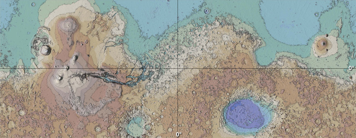
Click the image to view a larger, more detailed map.
The volcanoes of Mars
Olympus Mons
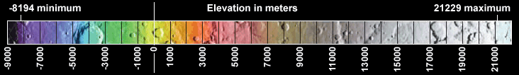
Olympus Mons located at 18.4°N and 226°E, this gently sloping shield volcano like the volcanoes that make up the Hawaiian Islands on Earth, is the highest point on Mars with an altitude of 21,229 m above the Martian areoid. It is also the highest mountain and largest volcano in the solar system. The volcano is as gentle as it is immense, with a diameter exceeding 500 km. Lava flows from Olympus mons and the neighboring volcanoes of Tharsis montes: Arsia mons (17,761 m), Pavonis mons (14,058 m), and Ascraeus mons (18,225 m) have redrawn the surface of this region. These lava flows are not heavily cratered, indicating that the eruptions took place during the Hesperian after the Noachian period of heavy asteroid bombardment.

Olympus Mons is probably located on a stationary plate above a deep hot spot. The stationary nature of the plate has kept Olympus Mons fixed above its hot spot which has allowed repeated eruptions to build it up over time and give it this very great height. An abrupt change of slope surrounds almost completely the volcano except for the north-eastern part in soft slope. This area of cliffs or steep escarpments which varies from 1 to 4 km in height questions the scientists on its origin.
Alba Mons
Alba Mons, located at 40.5°N and 250.4°E to the northwest of the Tharsis bulge, is exactly the opposite of the Hellas planitia impact basin. With remnants of ancient lava flows extending beyond 1,350 km from its summit and an approximate diameter of 550 km, it is the largest shield volcano on Mars and in the entire Solar System.

But Alba Mons is a low volcano, its highest point culminating only at 6.6 km which represents less than a third of the height of Olympus Mons. Its flanks have very gentle slopes: the average slope along the northern flank, the steepest, is 0.5 degrees, a value five times lower than that of the slopes of the other major volcanoes of Tharsis. This volcanic structure has no known equivalent in the whole solar system. The central part of the volcano is surrounded by a network of faults and fractures called Alba Fossae on the western flank and Tantalus Fossae on the eastern flank. The volcano also has very long, well-preserved lava flows that form radiating traces from the central region of the volcano. The great length of the flows (more than 300 km for some) implies a large volume of very fluid lava. Geological evidence shows that the volcanic activity of Alba Mons ended long before that of Olympus Mons and the volcanoes of Tharsis Montes. According to the analysis of volcanic deposits, Alba Mons would have been formed during the Hesperian to the very beginning of the Amazonian (Hartmann & Neukum), between 3.6 and 3.2 billion years before our era.
Elysium Mons
Elysium Mons is a volcano located at 24.8°N and 146.9°E in the Elysium quadrangle which is the second most important volcanic region of Mars, after the Tharsis bulge. It is 410 km wide and rises to 14,028 m above the Martian reference level and has a caldera of 14 km in diameter. Two other volcanoes are located in its immediate vicinity, Hecates tholus (4,500 m) to the north-northeast and Albor tholus (3,750 m) to the southeast, while a third, Apollinaris mons (3,000 m), is located much further to the southeast. These volcanoes are less effusive than those of Tharsis and would be more related to the stratovolcanoes, like, on Earth, Pinatubo or Pelee Mountain. Elysium Mons would have formed at least 3.65 billion years ago, at the very beginning of the Hesperian, and would have been still active 3.1 billion years ago, at the beginning of the Amazonian.

All the biggest...
The table below presents a synoptic synthesis of the main Martian volcanoes and the dating of their formation when it could be determined with the help of the cratering rate recorded on their different surfaces; these dates, when estimated, refer to the oldest terrains identified on the surface of each volcano, these having necessarily formed earlier, so that it can only be a lower limit to the age of these volcanoes what is reflected by the sign ≥ (greater than or equal to ). These dates are expressed in Ga (from Latin gigaannum) billion years. Source: Wikipedia.
| Name | Type | Coordinates | Altitude | Age | Alba Mons |
|
Shield volcano | 40,5° N et 250,4° E | ~ 6,600 m | ≥ 3,50 Ga |
|
|
|
Albor Tholus |
|
Gray vlocano | 18,8° N et 150,4° E | ~ 3,750 m | ≥ 2,16 Ga |
|
|
|
Amphitrites Patera |
|
Shield volcano | 58,7° S et 60,9° E | ~ 1,700 m | ≥ 3,75 Ga |
|
|
|
Apollinaris Mons |
|
Shield volcano | 9,3° S et 174,4° E | ~ 3,250 m | ≥ 3,81 Ga |
|
|
|
Arsia Mons |
|
Shield volcano | 8,4° S et 238,9° E | 17,761 m | ≥ 3,54 Ga |
|
|
|
Ascraeus Mons |
|
Shield volcano | 11,8° N et 255,5° E | 18,225 m | ≥ 3,60 Ga |
|
|
|
Biblis Tholus |
|
Tholus | 2,7° N et 235,4° E | ~ 7,000 m | ≥ 3,68 Ga |
|
|
|
Ceraunius Tholus |
|
Tholus | 24,0° N et 262,6° E | ~ 8,250 m | ≥ 3,75 Ga |
|
|
|
Elysium Mons |
|
Gray vlocano | 24,8° N et 146,9° E | 14,028 m | ≥ 3,65 Ga |
|
|
|
Hadriacus Mons |
|
Shield volcano | 32,1° S et 91,8° E | ~ −250 m | ≥ 3,90 Ga |
|
|
|
Hecates Tholus |
|
Gray vlocano | 32,1° N et 150,2° E | ~ 4,500 m | ≥ 3,40 Ga |
|
|
|
Jovis Tholus |
|
Tholus | 18,2° N et 242,5° E | ~ 3,000 m | ≥ 3,70 Ga |
|
|
|
Malea Patera |
|
Shield volcano | 63,4° S et 51,9°& E | ~ 0 m | n. d. |
|
|
|
Olympus Mons |
|
Shield volcano | 18,4° N et 226,0° E | 21,229 m | ≥ 3,83 Ga |
|
|
|
Pavonis Mons |
|
Shield volcano | 0,8° N et 246,6° E | 14,058 m | ≥ 3,56 Ga |
|
|
|
Peneus Patera |
|
Shield volcano | 57,8° S et 52,5° E | ~ 1,000 m | n. d. |
|
|
|
Pityusa Patera |
|
Shield volcano | 66,8° S et 36,9°& E | ~ 2,000 m | n. d. |
|
|
|
Syrtis Major |
|
Shield volcano | 7,9° N et 67,9° E | ~ 2,000 m | ≥ 3,75 Ga |
|
|
|
Tharsis Tholus |
|
Tholus | 13,4° N et 269,2° E | ~ 8,750 m | ≥ 3,71 Ga |
|
|
|
Tyrrhena Patera |
|
Shield volcano | 21,1° S et 106,5° E | ~ 3,000 m | ≥ 3,98 Ga |
|
|
|
Ulysses Tholus |
|
Tholus | 2,9° N et 239,4° E | ~ 5,500 m | ≥ 3,92 Ga |
|
|
|
Uranius Patera |
|
Patera | 26,0° N et 267,0° E | ~ 6,500 m | ≥ 3,70 Ga |
|
|
|
Uranius Tholus |
|
Tholus | 26,1° N et 262,3° E | ~ 4,500 m | ≥ 4,04 Ga |
|
|
|
|---|
Documentary sources, articles, databases:
Wikipedia |
USGS |
IAU |
Nasa |
MSSS
All the documents presented here are linked to their owners on their respective official site. ©Ifik |
Contact