Click the image to view a larger, more detailed map.
Altitudes and geographic coordinates
The exploration of the planet Mars has made it necessary to establish a reference frame in which to express altitudes and coordinates.
Zero altitude
Unlike the Earth where the zero altitude is based on the sea level near the lowest level of the highest low tide, Mars has no liquid expanse that could define a global equipotential surface. The zero level of the Martian altitudes had to be defined conventionally.
It is not possible to rely on its mean radius (3389.5 km) to define the Martian reference level of altitude: in such a reference, the equator would have a mean altitude of nearly 7 km above the reference level while the poles would be more than 13 km below, because the general shape of Mars is not a perfect sphere but a flattened spheroid at the poles.
The Viking program, developed by NASA in the early 1970s, had defined the 0 level as that of a spheroid with an equatorial radius equal to 3397.2 km. The Viking 1 lander landed on Mars on July 20, 1976 at 22.480° N and 47.967° W (planetographic coordinates) at an altitude of -2690 m relative to this reference frame.
The finalization of the reference frame took place at the beginning of the 21st’century from the altimeter readings of the Mars Orbiter Laser Altimeter (MOLA) of the Mars Global Surveyor (MGS) with the refinement of the measurements of the pressure on the ground during the successive exploration missions on and around the red planet. It has become possible to calculate a global equipotential from the average atmospheric pressure on a sufficiently tight network of points on the surface of the planet. Many intermediate data concerning the Martian geography were published in the 1970s, 1980s and 1990s and are often still available with values that have become erroneous today because they were established in an obsolete framework.
The Martian reference level of altitude 0 is conventionally established on Mars as that at which the mean atmospheric pressure is 610 Pa.
In practice, the pressure on the ground varies constantly due to climatic hazards (depressions and anticyclones) and especially due to the seasonal cycle of atmospheric carbon dioxide, in equilibrium with the carbon dioxide frozen in the polar ice caps, which induces considerable pressure variations over the entire Martian surface: Viking’1 Lander had thus recorded on its landing site extremes ranging from 680’Pa in summer to nearly 900’Pa in autumn. This is what makes it so difficult to determine the Martian reference level according to the standard pressure on the ground, so much so that before the year 2000 the inaccuracy of altitudes could reach 4 to 6 km.

Zero Meridian
The zero meridian of Mars was defined in 1830 by the German astronomers Wilhelm Beer and Johann Heinrich von Mädler based on a small circular formation near the equator which they used to determine the rotation period of Mars. This circular formation was later used by the Italian astronomer Giovanni Schiaparelli in 1877 as the zero meridian for his longitudes. The French astronomer Camille Flammarion named it Sinus Meridiani (Meridian Bay), from which comes the current name Meridiani Planum designating this region. The Airy crater was chosen in this region to more precisely materialize the meridian 0 and, following the mapping of the surface of Mars obtained in 1972 by the Mariner 9 probe with an average resolution of the order of one kilometer, the center of the small Airy-0 crater, located inside the Airy crater and only 500 m wide, was chosen to position the meridian 0 on Mars. Ultimately, the Viking 1 lander has served as the reference since 2018 with an officially assigned longitude of 47.967° W in planetographic coordinates. In the second planetocentric system, with altitude 0 defined previously, the landing point of the Viking 1 Lander becomes 22.697° N and 312.778° E at an altitude of about -3300 m. Source : Wikipedia
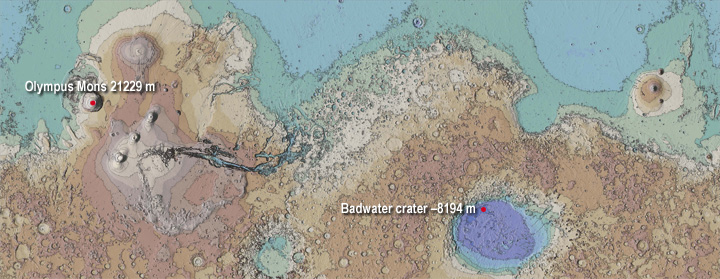
Extreme differences in altitude…
Spectacular events have determined the lowest and highest points on Mars. The lowest point is due to a huge asteroid impact that formed the Hellas impact crater. The highest point is due to the repeated eruptions of Olympus mons. Although Mars is a planet half the size of Earth, its extreme heights and depths are enormous in comparison.
Hellas Planitia with a diameter of 1500 to 1900 km and a depth ranging from 6000 to 7500 m below the Martian datum, is the largest and deepest visible impact basin on Mars. Its low point at -8194 m altitude is also the lowest point on the Martian surface. It is located in the Badwater crater (33° S, 62° E indicated by a square with a white border on the picture).


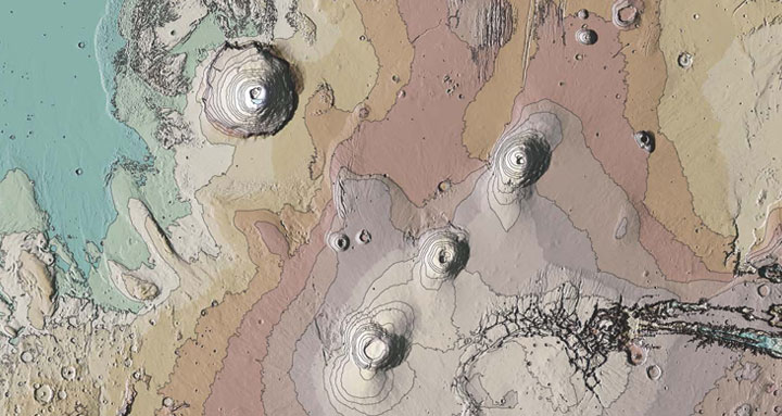
The summit of Olympus Mons is the highest point on Mars with an altitude of 21229 m above the reference level. It is also the highest mountain and the largest volcano in the solar system.

Documentary sources, articles, databases:
Wikipedia |
USGS |
IAU |
Nasa |
MSSS
All the documents presented here are linked to their owners on their respective official site. ©Ifik |
Contact