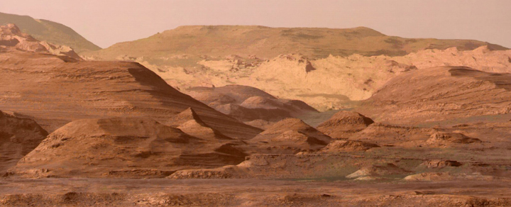
Photo: The foothills of Mount Sharp, in the morning. This composite image looking
towards the higher regions of Mount Sharp was taken on September 9, 2015 by Curiosity. In the foreground, about 3 kilometers
from the rover, is a long ridge of hematite, an iron oxide. Just beyond is a rolling plain rich in clay minerals followed by a multitude of rounded knolls,
all rich in sulphate minerals. The evolution of the mineralogy in these layers of Mount Sharp suggests a changing environment
in early March, although it all implies exposure to water billions of years ago. Further in the image, there are light-toned rock cliffs that may have formed
in a drier time and are now heavily eroded by winds.
Mount Sharp, the central peak of Gale Crater, so named by NASA, was officially named
Aeolis Mons by the IAU (International Astronomical Union) in May 2012. The IAU named a large crater 152.08 km in diameter located
west of Gale Crater after Robert Sharp. Robert Sharp, is a NASA planetary geologist who worked for the first Martian missions
and died in 2004.
Fascinated by the processing of images sent by probes exploring the solar system, Thomas Appéré regularly produces mosaics like this one and colorizations
of unpublished images, which he then shares on social networks. Credit: NASA/JPL-Caltech/ MSSS/Thomas AppéréThomas Appéré.
Glossary of terms used on the site
| Name | Description |
|---|---|
| Albedo | When solar radiation reaches the ground of a planet it is partly reflected. The albedo is the fraction of the solar
energy that is reflected back to space. The more a surface is reflective, the higher its albedo is. Its value is between 0 and 1. An albedo feature is a region generally spread over the surface of an object in the solar system that is distinguished by a marked contrast with neighbouring regions. They are the first structures to have been identified, named and studied on the surface of the stars seen from the Earth. Lunar seas are albedo features identified by the dark spots they form on its surface. Observed with a telescope since the 17th century, the oldest albedo feature identified outside the Moon is Syrtis Major, recorded by Christian Huygens on a sketch of Mars made in 1659. |
| Classical albedo features | The classical albedo features of Mars are those bright or dark areas identified by early astronomers. The most popular nomenclature system was devised by Giovanni Schiaparelli, who used names from classical antiquity, in 1878. The improved understanding of Mars through space probes has made many classical names obsolete for mapping purposes; however, many of these ancient names have been reused in the creation of more recent maps. |
| Caldeira | A caldera is a large circular or elliptical depression, often flat-bottomed, located at the heart of some large volcanic edifices. |
| Decimal coordinates | The coordinates used for Mars are all decimal and positive, counted from 0 to 360° and increasing towards the east or west depending on the system used (see the two following definitions). That said, the decimal GPS type coordinates (for our planet) are expressed with the following characteristics - latitude between 0° and 90°: Northern Hemisphere, - latitude between 0° and -90°: Southern hemisphere, - longitude between 0° and 180°: East of the reference meridian (Greenwich), - longitude between 0° and -180°: West of the reference meridian. |
| Ecliptic | The ecliptic plane is the absolute geometric plane containing the orbit of a planet around the Sun. The ecliptic plane is also the reference plane of the celestial coordinate system called the ecliptic coordinate system. |
| EDT/PDT | EDT for Eastern Daylight Time, also designated UTC-04:00, is a time zone that is four hours behind Coordinated Universal Time (UTC) based on the Greenwich time zone. PDT for Pacific Daylight Time, also designated UTC-07:00, is a time zone that is seven hours behind Coordinated Universal Time (UTC) based on the Greenwich time zone. |
| Gray or explosive (volcano) | Gray volcanoes get their name from the predominantly gray color of their eruptive products. They are explosive volcanoes emitting lava that is sufficiently viscous that it does not form a lava flow but accumulates at the point of exit, forming a needle or dome of lava. When this more or less stable mass of lava collapses or explodes in whole or in part, a volcanic plume of ash and rock debris rises miles above the volcano, and fiery clouds may sweep down its slopes at hundreds of miles per hour, for several miles. |
| IAU | The International Astronomical Union (IAU) is an international non-governmental organization of professional astronomers engaged in astronomical research and education. Its purpose is to coordinate the work of astronomers throughout the world and to promote and safeguard the science of astronomy through international cooperation. It acts as a recognized authority and has a number of working groups including the Working Group on Planetary System Nomenclature (WGPSN) which maintains astronomical naming conventions and nomenclature of planetary bodies and the Working Group on Star Names (WGSN) which catalogs and standardizes proper names of stars. The IAU was founded in 1919 and is based in Paris. |
| Martian year | The duration of a Martian sidereal year (the time taken by the planet to make one revolution around the Sun) is about 686.98 solar days on Earth or 668.5991 sols (definition of sols below). The length of the tropical year (or equinox or solar year) depends on the point used to measure its beginning, usually an equinox or solstice (the Gregorian calendar uses for example the spring equinox of the northern hemisphere). On Earth, the difference between the various tropical years is of no consequence. On Mars, on the other hand, taking the spring equinox as its origin leads to a tropical year with 668.5907 sols, the boreal summer solstice with 668.5880 sols, the autumn equinox with 668.5940 sols, and the boreal winter solstice with 668.5958 sols. It is possible to take an average and define the Martian tropical year at 668.5921 sols. |
| MGS | Mars Global Surveyor is an American robotic space probe developed by NASA's Jet Propulsion Laboratory and launched November 1996. MGS was a global mapping mission. As part of the larger Mars Exploration Program, Mars Global Surveyor performed atmospheric monitoring for sister orbiters during aerobraking, and helped Mars rovers and lander missions by identifying potential landing sites and relaying surface telemetry. |
| NASA | The National Aeronautics and Space Administration, better known by its acronym NASA, is the government agency responsible for most of the U.S. civil space program. Aeronautics research is also part of its domain. Since its inception in the late 1950s, NASA has played a dominant role worldwide in human space flight, solar system exploration and space research. |
| Permafrost | Permafrost is the part of a gelisol that is permanently frozen and therefore impermeable. Gelisol, a particular soil of cold regions, (from the Latin gelare which means "to freeze") can be composed of permafrost at the depth and at the surface of a part, called mollisol, which can thaw during part of the year on Earth and probably does not exist on Mars due to the current very low temperatures In the World Wide Baseline for Soil Resources (WRB), gelisols are known as Cryosols. |
| Planetographic coordinates | Latitudes were initially determined in a planetographic framework consisting in calculating them directly from the distances extrapolated on the images obtained from the surface of the planet with respect to a grid of coordinates projected on this surface. In this system, used by the Viking program, the longitudes are expressed in positive values from 0 to 360° increasing towards the west. Viking 1 had landed in the western part of Chryse Planitia at 47.97° W longitude. The IAU database for Mars has only 22 old planetographic coordinates: 9 name approvals in 1973, 1 in 1987, 8 in 2006 and 4 in 2011. |
| Planetocentric coordinates | Since the beginning of the century, the planetocentric system tends to replace the older planetographic system, although both were validated by the IAU in 2000. In this new system, latitudes are calculated from the angle formed by a point on the surface with the equatorial plane of the star and counted from the equator from 0° to +90° towards the north pole and from 0° to -90° towards the south pole, while the longitudes are expressed in positive decimal value from 0 to 360° increasing towards the east. In this system, and with the altitude 0 defined, the landing point of the Viking 1 Lander probe becomes 22.697° N and 312.778° E at an altitude of about -3300 m. Almost the entire IAU database for Mars gives planetocentric coordinates. |
| Quadrangle | In geodesy and planetology, a quadrangle is a curvilinear quadrilateral bounded by two meridians and two parallels, which gives it a quadrangular geometry. |
| Sexagesimal coordinates | Sexagesimal coordinates have three components that are becoming more and more precise: degrees, minutes and seconds. Each component is a positive number, integer for the first two, and decimal for the seconds in order to obtain a great finesse of positioning. One degree of angle includes 60 minutes of angle, and one minute of angle includes 60 seconds of angle. Unlike decimal coordinates, sexagesimal coordinates cannot be negative. A latitude is counted from 0° to 180° on each side of the 0 meridian. The final letter E or W specifies the east-west position with respect to the reference meridian. The letter N or S of the latitude specifies the northern or southern hemisphere in relation to the equator. |
| Shield volcano | A shield volcano is a volcano characterized by its eruptions with fluid lavas, the majority of which spread over the surface of a volcano, as opposed to explosive eruptions that emit mainly fragmented lavas into the atmosphere. Its relatively flat or rounded cone shape resembles a shield on the ground. |
| Sol | The sidereal day is the time it takes for a planet to make one revolution on itself, independently of its revolution around the Sun. Solar time is a more complex notion including mean solar time and true solar time. Mean solar time is based on a fictitious sun moving around the equator at a constant speed throughout the year. This average speed is one revolution in 24 hours. The true solar time is based on the apparent solar day, which is the duration between two successive returns of the Sun to the local meridian. The inclination of the axis of a planet with respect to its ecliptic plane (definition above), the eccentricity of its orbit and the variability of its speed of displacement on its orbit (first and second laws of Kepler) make this duration vary throughout the year. The average duration of the Martian sidereal day is 24 hours 37 minutes 22.663 seconds and the average duration of the Martian solar day, called "sol", is 24 hours 39 minutes 35.244147 seconds (or 88775.244147 seconds). The corresponding values for the Earth are respectively 23 hours 56 minutes 4.2 seconds (86164 seconds) and 24 hours 0 minutes 0 seconds (or 86400 seconds). The Martian day is usually divided, for convenience, in the same way as the Earth day: 24 hours of 60 minutes, each minute being itself divided into 60 seconds. These Martian hours, minutes and seconds are therefore, by construction, also longer than their terrestrial counterparts. |
| Stratovolcano | Stratovolcanoes take on a slender conical shape because of their pasty lava that flows with difficulty, with fallout of ash and slag occurring preferentially near the volcanic vent. The shape of the volcano is usually conical or nested when, as a result of the volcano's explosion, a new cone forms in the crater or caldera (definition of caldera above). |
| USGS | The United States Geological Survey is a U.S. government agency dedicated to the earth sciences. USGS activities are divided into five areas: biology, geography, geology, water, and geospatial information. |
Documentary sources, articles, databases:
Wikipedia |
USGS |
IAU |
Nasa |
MSSS
All the documents presented here are linked to their owners on their respective official site. ©Ifik |
Contact