
|
|
NASA’s Ingenuity Mars Helicopter took this color image during its fourth flight on April 30, 2021. “Airfield B,” it’s new landing site, can be seen below; it will seek to set down there on its fifth flight attempt. Credit: NASA/JPL-Caltech. |
2021 The first tests of the first flying machine on Mars
On the eve of a fifth flight of the first Mars helicopter, Josh Ravich, Ingenuity Mars mechanical engineering manager at NASA's Jet Propulsion Laboratory, writes the article below. Source: mars.nasa.gov
Why Ingenuity’s Fifth Flight Will Be Different
Around the time of our first flight, we talked a lot about having our “Wright brothers moment” at Mars. And that makes a lot of sense, since those two mechanically-minded bicycle builders executed the first powered, controlled flight on Earth, and we were fortunate enough to do the same 117 years later – on another planet.
But the comparisons shouldn’t stop with a first flight. Ingenuity’s fifth flight is scheduled for Friday, May 7. As always (at least so far), our targeted takeoff time is 12:33 p.m. local Mars time (3:26 p.m. EDT, or 12:26 p.m. PDT), with data coming down at 7:31 p.m. EDT (4:31 p.m. PDT). Ingenuity will take off at Wright Brothers Field – the same spot where the helicopter took off and touched back down on all the other flights – but it will land elsewhere, which is another first for our rotorcraft. Ingenuity will climb to 16 feet (5 meters), then retrace its course from flight four, heading south 423 feet (129 meters).
But instead of turning around and heading back, we’ll actually climb to a new height record of 33 feet (10 meters), where we can take some color (as well as black-and-white) images of the area. After a total flight time of about 110 seconds, Ingenuity will land, completing its first one-way trip. When it touches down at its new location, we will embark on a new demonstration phase – one where we exhibit what this new technology can do to assist other missions down the road.
|
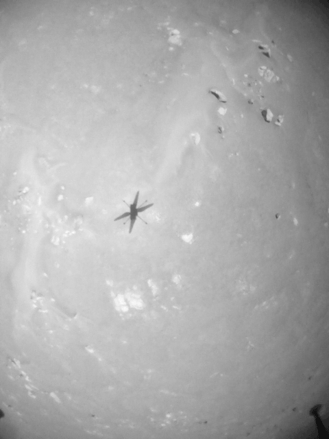
Photo opposite: NASA’s Ingenuity Mars Helicopter took these images on its fourth flight, on April 30, 2021, using its navigation camera. The camera, which tracks surface features below the helicopter, takes images at a rate at which the helicopter’s blades appear frozen in place, despite making 21 full rotations in-between each image. In flight, the blades spin at 2,537 rpm. The images are aligned entirely using Ingenuity's on-board position tracking system highlighting the stability and accuracy of the navigation algorithm. 
Ingenuity photographed by Perseverance. Credit: NASA/JPL-Caltech |
The Wrights did that, too. They didn’t quit after one successful flight with Flyer I, or even the other three flights they did on that historic December day in 1903. They flew higher and farther in an upgraded Flyer II in 1904, and even higher and farther with 1905’s Flyer III. By 1908, the Wrights felt they had conquered the air (at least enough) to begin looking at what kind of practical applications an airplane could be used for. That year they flew the first air passenger (Charles Furnas, their mechanic) and began demonstrating how scouting from an aerial perspective could become a thing.
So in a sense, over the course of three weeks and four flights, the Ingenuity team has gone from the Wright brothers of 1903 to the Wright brothers of 1908, but in weeks rather than years. We’ve been able to do this because the rover, which carries the helicopter’s communications base station, will remain in the general vicinity for many sols (Martian days) and because on the fourth flight, we actually scouted for a landing zone over 100 meters (328 feet) away. The digital elevation maps put together by the Ingenuity team gave us confidence that our new airfield is flat as a pancake – a good thing when you have to land on it.

|
Photo opposite: May 06, 2021. NASA’s Ingenuity Mars Helicopter’s fourth flight path is superimposed here atop terrain imaged by the HiRISE camera aboard the agency’s Mars Reconnaissance Orbiter. Crédit: NASA/JPL-Caltech/Université de l’Arizona. Large image
Which leads me back to our fifth flight. We are traveling to a new base because this is the direction Perseverance is going, and if we want to continue to demonstrate what can be done from an aerial perspective, we have to go where the rover goes. The Wrights did the same in 1908 – even traveling all the way to LeMans, France, to demonstrate the capabilities of their aircraft. I think a lot about the Wrights during our flights. I’m sure part of the reason is that I (along with teammate Chris Lefler) had the honor of attaching the small swatch of material from the lower left wing of Flyer I to Ingenuity. But it’s more than that. The Wrights showed what could be accomplished with a combination of teamwork, creativity, and tenacity – and a bit of ingenuity and perseverance. |

|
|
Photo above: Ingenuity carries a small swatch of muslin material from the lower-left wing of the Wright Brothers Flyer I. Located on the underside of the helicopter's solar panel (the dark rectangle), the swatch is attached with dark orange polymide tape to a cable extending from the panel, and then further secured in place with white polyester cord used to bind cables together. A gray dot of epoxy at the intersection of the three wraps of cord prevents the lacing from loosening as the rotor blades (upper pair seen at bottom of image) rotate at up to 2,400 rpm. The entire process, from enclosing the material in the plastic to affixing it onto the helicopter took, approximately 30 minutes. |
Jezero, the landing site chosen by NASA

Photo: This image of February 20, 2021 (sol 3), reconstructed by Thomas Appéré from several photos taken by the Mastcam-Z camera, shows the rear of the rover and the double delta of the river valleys Neretva Vallis, to the west, and Sava Vallis, further north. In the background we can guess the edge of the crater. Jezero is an impact crater of 49 km diameter located in the Syrtis Major quadrangle at the western edge of Isidis Planitia, formed in the Noachian period about 3.7 billion years ago. At two different times in its history Jezero was probably a lake of liquid water. An overflow break was created in the east forming the Pliva Vallis. Geologists believe that clay alluvium from both valleys filled the bottom of Jezero to a thickness of more than a kilometer. Clay forms in the presence of water, so there was water there, and potentially life as well, which will be sought by Perseverance's scientific tools. Credit: ©NASA/JPL-Caltech/ASU/MSSS/Thomas Appéré.

Credit: from ESA/DLR/FU, Berlin.
Documentary sources, articles, databases:
Wikipedia |
USGS |
IAU |
Nasa |
MSSS
All the documents presented here are linked to their owners on their respective official site. ©Ifik |
Contact