
Photo: After spending the Martian winter halfway up Marathon Valley Gap, which opens to the northeast and slopes gently down to the floor of Endeavour Crater, Opportunity climbed back up to study rock samples and photograph this view. The northeastern and eastern rims of Endeavour Crater appear on the distant horizon. Smaller impact craters can be seen in the barrier of this large 22 km diameter crater. The scene merges several Pancam shots between April 16 and May 15, 2016 corresponding to sols 4,347 to 4,375. The rover first entered Marathon Valley in July 2015. The valley's name was chosen because Opportunity's arrival there, along the western rim of Endeavour Crater, coincided with its first 42 kilometers covered, a distance identical to the Olympic marathon. Crédit : NASA/JPL-Caltech.
Impact craters
An impact crater is a depression of more or less circular shape resulting from the collision of an object on another of greater size. When the depression is much shallower than wide we speak of an impact basin. The expression is particularly used to designate the depression resulting from a cosmic impact, i.e. the collision of celestial objects (an asteroid or a comet) hitting any other solid body moving in space and large enough for the power of the impact not to cause its destruction.

Credit: from Wikimedia / Don Davis (work commissioned by NASA) / Public domain.
Impact craters on Mars larger than 1 km exist by the hundreds of thousands, but only a little over a thousand of them have names. Names are assigned by the International Astronomical Union after petition by concerned scientists, and in general, only craters that have significant research interest are named. Martian craters are named after famous scientists and science fiction authors, or, if less than 60 km in diameter, after cities on Earth. Apart from the Moon, no other body has as many named craters as Mars.
To consult the list of
craters named by the IAU
The impact basins
When a meteorite hits the ground, it quickly penetrates it by vaporizing under the enormous energy of the impact. The ground behaves like an elastic material and sinks deeply while vaporizing and fracturing. After a few seconds, the hole reaches its maximum size, it is the transitory crater.
Then, the ground takes its place, it is the rebound. In the end, only a final crater remains, the shape of which depends on the volume of vaporized and ejected subsoil, the residual compression in the rocks, the power of the rebound, the landslides, the slumping of the walls and the fallout. The final crater will take some time to stabilize before erosion cuts into it.
It is the angle at which the meteorite strikes the ground that affects the circularity of the crater, not the shape of the meteorite. The steeper the angle, the more elongated the crater will be, but it is below an angle of 45° that the elongation will be notable.
Today, most large craters are only visible in their eroded form and one can only measure an apparent crater whose shape is more or less visible depending on the degree of erosion, sediment recharging or subsoil movement.
During the rebound, and when the size of the crater is sufficient, the center rises more than the surroundings, a bit like a drop of water. A more or less important central uplift is formed, which can rise higher than the bottom of the crater. A more or less pronounced central peak is then formed.
When the meteorite is large enough to pierce the crust and cause magmatic outpourings, it is called a basin and no longer a crater. Source : Wikipedia
Mars has three major impact basins:
Hellas Planitia
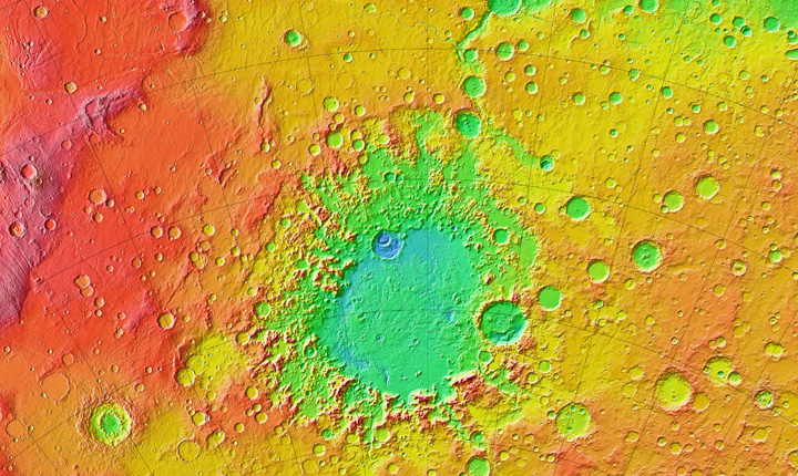
With a diameter of 1,500 to 1,900 km and a depth ranging from 6,000 to 7,500 m below the Martian datum, Hellas Planitia is the largest and deepest impact basin visible on Mars. Its low point at -8,194 m altitude is also the lowest point on the Martian surface. It is located in the Badwater crater (33°S and 62°E indicated by a square with a white border on the picture).

Formed by an impactor measuring about 550 km, Hellas is the most visible feature of the southern highlands. Its very elliptical shape suggests that Hellas Planitia could be a double impact basin (two circles mark the approximate positions of the supposed impacts) or an oblique impact event which would explain the absence of inner impact rings. The edges of the basin are severely damaged, only the western half is more or less intact. To the east, the crater rim is pierced by 600 km wide Hesperia planum and has large flow channels (Dao Vallis and Harmakhis Vallis) caused by volcanic processes where hot magma melted huge amounts of ice in the frozen ground causing very large "blast floods". To the south, the crater rim has disappeared replaced by the Malea Planum for 900 km particularly important for the climatic conditions of the basin because it induces the influx of cold air that flows from the highlands south of the pole. The discontinuous edge of Hellas rises in places up to 5000 m above the interior plains.
Argyre Planitia
Argyre Planitia is an impact basin 800 km in diameter and -5,200 m in elevation located in the southern hemisphere of Mars and centered at 49.7°S and 316.0°E in the Argyre Quadrangle, between Solis Planum and Bosporos Planum to the northwest, Noachis Terra to the east, and Aonia Terra to the southwest. It is the second largest impact structure on Mars after Hellas Planitia, before Isidis Planitia. Its formation would be contemporary to that of these two other structures, and would date back to the end of the Noachian, perhaps in relation to the hypothetical great late bombardment dated, according to lunar samples, from 4.1 to 3.8 billion years before our era.
The basin is surrounded by areas of rugged relief with concentric ring structures generally of Hesperian date. Irregular faulted escarpments can be seen to the west and well away from the basin, including Argyre Rupes to the southwest, Bosporus Rupes to the northwest quite close to the basin, and the more isolated Ogygis Rupes farther north. The basin itself is surrounded by mountain ranges, crossed in a radial way by valleys evoking river beds.
Isidis Planitia
Isidis Planitia is an impact basin east of Syrtis Major Planum and on the edge of Utopia Planitia. It is partly in the Syrtis Major quadrangle and partly in the Amenthes quadrangle. Centered by 12.9°N and 87.0°E and extending on 1,200 km, it is the third largest impact structure after Hellas Planitia and Argyre Planitia. Isidis is probably the last large basin to have formed on Mars, since it was formed about 3.9 billion years ago during the Noachian. Because of the dust cover, it generally appears bright in telescopic views, and has been mapped as a classic albedo feature, Isidis Regio.
The geological history of parts of Isidis is complex, especially in areas near the Deuteronilus contact. This contact is the supposed edge of a vast Martian ocean. Researchers have found evidence of a late Hesperian/early Amazonian sea in the area. The sea would have frozen quickly.
Just west of Isidis is Syrtis Major Planum, a low-relief shield volcano that is an important feature of the dark albedo of Mars, which formed after the basin.
The British probe Beagle 2, of the Mars Express mission, was supposed to land on December 25, 2003 in the east of Isidis Planitia at 10.6°N and 90°E, but finally landed 5 km from its objective (11.5265°N and 90.4295°E) and was lost.

Documentary sources, articles, databases:
Wikipedia |
USGS |
IAU |
Nasa |
MSSS
All the documents presented here are linked to their owners on their respective official site. ©Ifik |
Contact